|
This Permian Terrestrial deposit was formed as a dune eolian deposit, and exhibits the typical cross bedding and sandy texture of such deposits. With an age of 270 - 275 million years old, several very different lithologies are represented. Fossils are very scarce in the red beds, sometimes worm burrows and plant impressions can be found. The Schnebly Hill formation is divided in two by the Fort Apache Limestone. This represents a marine transgression onto the dune fields for a short time period. The lowest member in the formation is called the Rancho Rojo member. This bright red sand wave deposit was formed when dune sands enter the marine environment by blowing wind. The resulting subsurface sand forms low rolling waves which have a unique lithology. The Rancho Rojo member can only be found near the village of Oak Creek. The next layer up is the Bell Rock member. This sandstone and siltstone deposit formed when blowing sand settled onto tidal flats on the edge of the Pedregosa Sea. The resulting layers are flat and very laminar, with occasional wave ripples on flat surfaces. Famous landmarks in Sedona Arizona such as "Bell Rock" and "Courthouse Butte" consist mainly of the Bell Rock member, with a bit of Fort Apache Limestone at the top. The Fort Apache Limestone is next in the sequence, and is covered in a separate section. Click here to go there. The final member of the Schnebly Hill formation is the Sycamore Pass member. This is the red eolian deposited sandstone that sits on top of the Fort Apache Limestone. The cross bedding and sand grain characteristics indicate that this formation is a coastal dune deposit, ranging far from the shores of the retreating Pedgregosa Sea. CLICK ON THE FOLLOWING SELECTIONS FOR A LARGER VIEW:
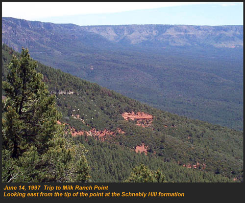
This image, which I took from the top of the Mogollon Rim at Milk Ranch Point shows the red beds outcropping on the slope of the Rim. Just above can be seen the Permian Fort Apache Limestone, which is a deep water marine transgression onto the dune deposits.
In Sedona, where we took this one, the Schnebly Hill formation can be seen weathering into magnificent columns and buttes that make the area famous for its spectacular scenery.
Also taken in Sedona, this butte shows the multi-colored banding that is typical of the Schnebly Hill formation when it conformably grades into the Coconino Sandstone which overlies it.
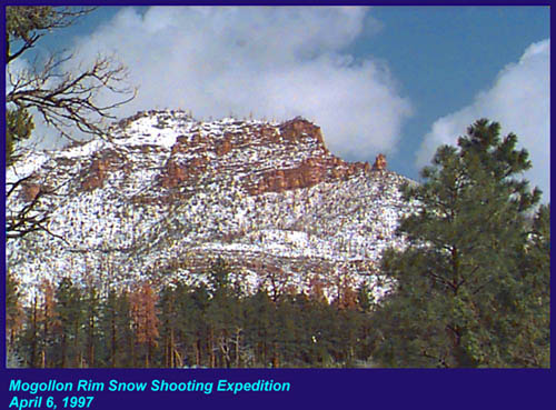
The Schnebly Hill formation north of Payson, down Tonto Creek Road. We often have heavy snows here, and the opportunity to capture the reddish brown sandstones with a dusting of snow is a real treat!
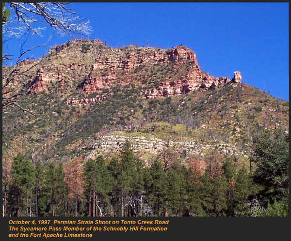
Just East of the above view from the Tonto Creek area, the Schnebly Hill formation is seen here forming blocky cliffs and with a bit of angular disconformity to the more level white block wall of limestone of the Fort Apache Limestone.
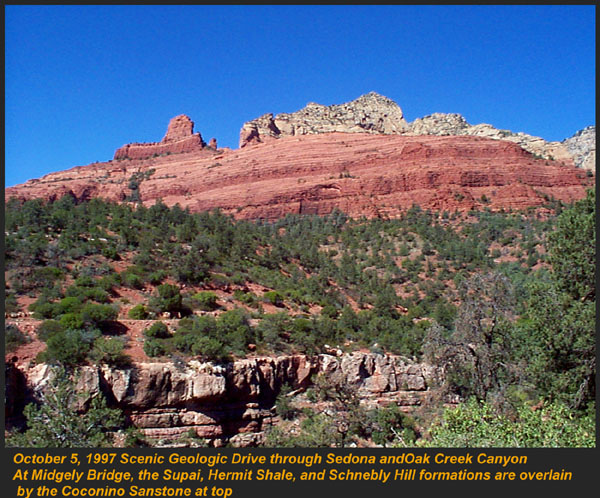
One of my most favorite areas to show the Permian stratigraphy is at Midgley bridge in Sedona. This shot taken from the edge of Oak Creek at the bridge, shows the Supai formation at the bottom as a massively bedded limy shale and mud stones, topped by the Hermit Formation which characteristically forms weathered slopes of very soft red shales, over this is the Bell Rock member of the Schnebly Hill formation, showing its marine tidal flat bedding. This red ridge by the way is known locally as "ship rock". The marine Fort Apache Limestone forms the base of the ships "stack". On the top, the stack itself is made of eolian deposited Sycamore Pass member of the Schnebly Hill formation. To top the view, the ridge behind is solid Coconino Sandstone! BELL ROCK MEMBER
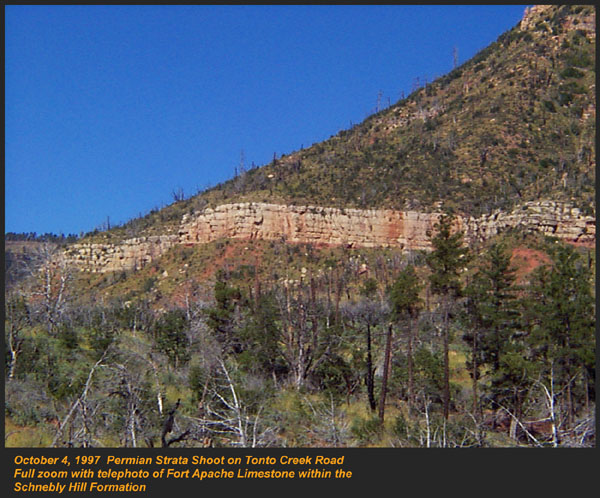
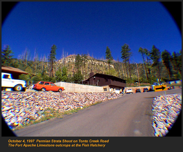
The Fort Apache Limestone is a dominant feature in the landscape in this view taken up on the Mogollon Rim near the trout fish hatchery near the town of Tonto Creek. Only about 80 feet thick here, it is non fossiliferous, and very blocky in appearance. I was not able to get very near the outcrop, because it is on private land, but the reddish Bell Rock member of the Schnebly Hill formation can be seen directly under the cliff.
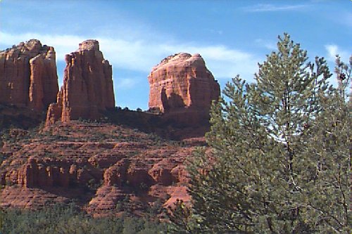
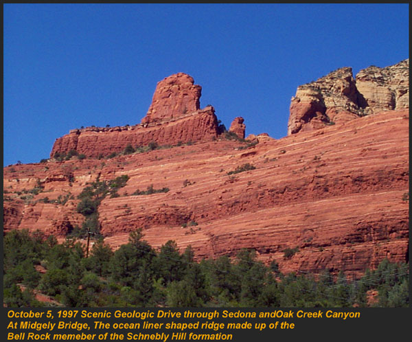
Bell rock, the butte that the Bell Rock member of the Schnebly Hill formation was designated as the type locality for, is one of the most photographed formations in all of Arizona. It can be easily seen that the marine tidal flat deposited shales and sandstones are perfectly flat laminations all the way up the hill. Occasional limy shale or limy sandstone beds inter layer the sandstones within the sequence. The best view of this butte is along the roadway between the village of Oak Creek, and Sedona.
I am showing this close up of Ship Rock, next to the Midgley bridge in Sedona, to show the intricate and very numerous laminations in the Bell Rock Member of the Schnebly Hill formation. When examined up close, the lighter layers are more limy, and finer grained than the deep red layers. Look how thin now the Fort Apache Limestone is getting at the top of the ridge. This member eventually pinches out further down the road, marking the end of the marine transgression onto the dunes. SYCAMORE PASS MEMBER
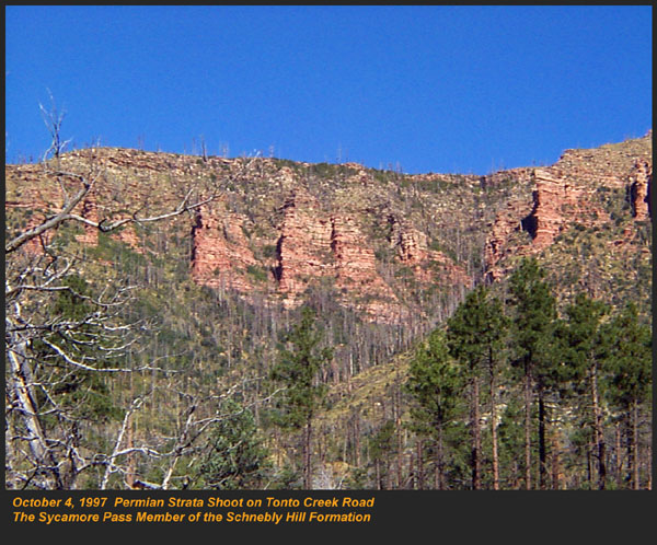
This image, also up near the fish hatchery down Tonto Creek road shows the Sycamore Pass member of the Schnebly Hill formation forming rugged cliffs and escarpments. The dune/tidal deposit has hundreds of individual layers seen here, each representing a different period of deposition cycle.
The road to the Tonto Creek Fish Hatchery offers a splendid view of the Fort Apache Limestone and Sycamore Pass Member of the Schnebly Hill Formation. Here, I was at the hatchery itself, looking north.
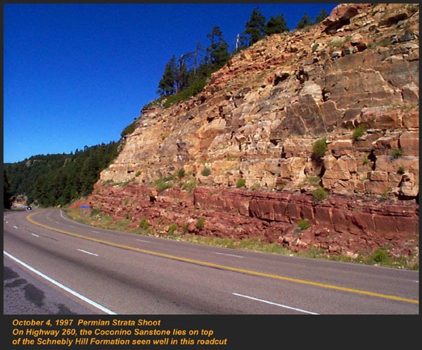
In this road cut, on Highway 260 out of Christopher Creek, the yellow Coconino sandstone is seen sitting conformably on the upper Sycamore Pass member of the Schnebly Hill sandstone. The red Schnebly here is more laminated and represents a tidal zone deposit, and the Coconino contains many more cross beds of eolian origin, indications of a change to a more arid dune type environment.
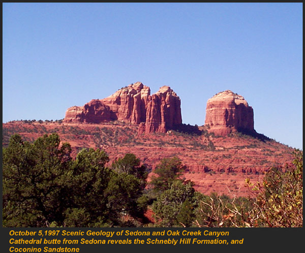
Cathedral Butte, located in the center of Sedona, is a chain of buttes formed of the Sycamore Pass member of the Schnebly Hill formation. Consisting primarily of red bed sandstones, they are dune deposits cemented by iron oxides. The tops of the buttes are capped by the Permian Coconino Sandstone. As an amusing aside, at the very bottom of the picture, through a hole in the trees, you can see the slope forming Hermit Shale. We were searching for fossils this day in the Hermit, and found some calamities trunks and roots in this area.
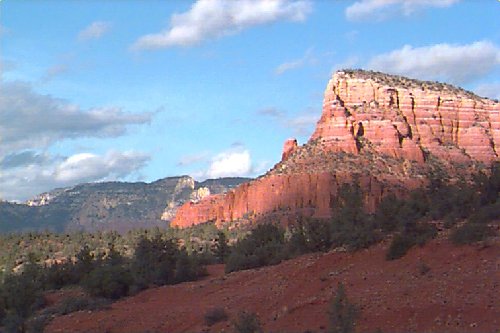
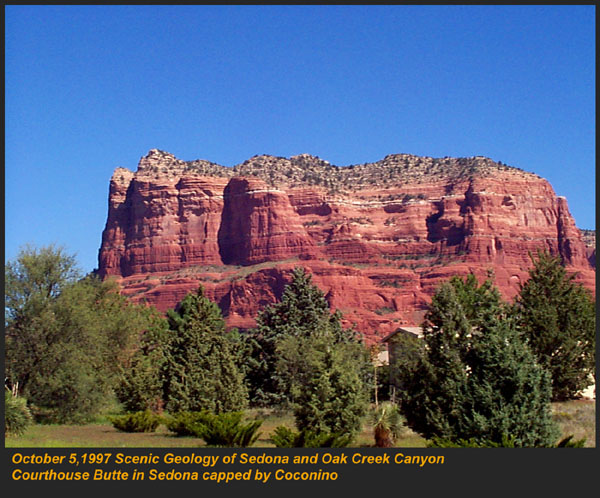
Courthouse Butte, near the Village of Oak Creek, is a splendid example of the Sycamore Pass member of the Schnebly Hill formation. The massive red rock is highly cross bedded up close, and reveals its dune origin nature. The butte is capped by the Coconino sandstone, which is also eolian in origin. RANCHO ROJO MEMBER
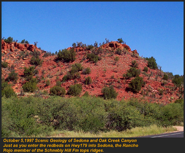
Along highway 179, going toward Sedona, you are first greeted with the red rock splendors with this set of low hills, west of the roadway. The base of the hill is the Hermit Shale, however the very sandy ledge on the top is the rare Rancho Rojo member of the Schnebly Hill formation. It is located stratigraphically at the very bottom of the Schnebly, and can be considered here as the basal unit. We found when climbing up to this deposit, flat plates and layered fine grained sandstones. A few fossils were found, primarily plant stem impressions, and root casts.
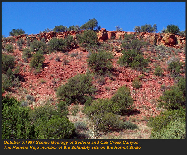
This view of the Rancho Rojo reveals clearly the resistance to weathering that forms cliffs and escarpments. The underlying Hermit Formation by comparison, breaks apart easily, and forms slopes of broken shales seen here. This was taken a few hundred feet down the road from the above image, on Highway 179 toward Sedona.
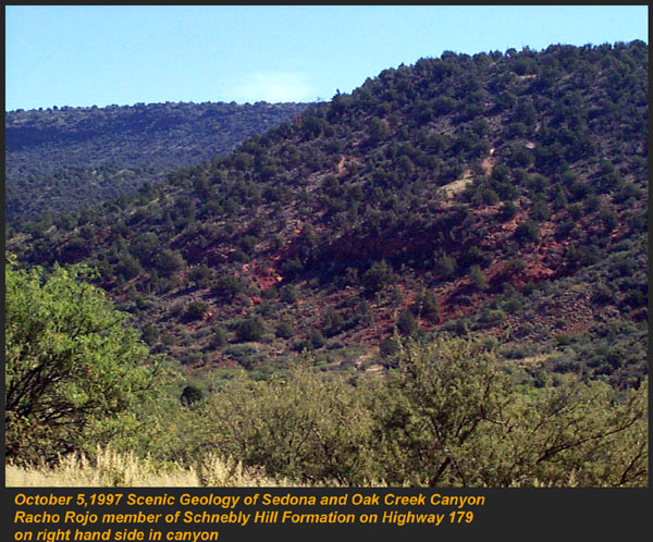
On the far side of a graben (A canyon formed when the surface rock pulls apart) forming a creek, the Rancho Rojo deposits seen as bright orange, are capped with basalt flows of tertiary age. This is on Highway 179 going toward Sedona. |